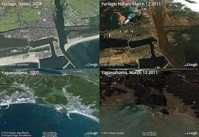
Both Google and NASA are releasing satellite images depicting the devastation last week's earthquake and tsunami caused in Japan.
Google teamed up with GeoEye, a satellite imagery company, to make images of the affected area available for people to view in Google Earth or Google Maps.
Ryan Falor, a member of the Google Crisis Response team, noted in a blog post over the weekend that the images are being made available to aid organizations in an attempt to assist their rescue efforts.
"We hope this new updated satellite imagery is valuable for them as well as everyone else following this situation to help illustrate the extent of the damage," wrote Falor.
"You can also follow @earthoutreach on Twitter to stay up to date with our mapping and imagery efforts."
At NASA, scientists used a Multi-angle Imaging SpectroRadiometer instrument on the Terra spacecraft to show before-and-after imagery of the havoc wrought by the tsunami. The NASA images show that flooding caused by the tsunami extended more than 2.5 miles inland from the eastern shoreline. The white sand beaches visible in image taken before the tsunami now are covered by water.
Read More
Google teamed up with GeoEye, a satellite imagery company, to make images of the affected area available for people to view in Google Earth or Google Maps.
Ryan Falor, a member of the Google Crisis Response team, noted in a blog post over the weekend that the images are being made available to aid organizations in an attempt to assist their rescue efforts.
"We hope this new updated satellite imagery is valuable for them as well as everyone else following this situation to help illustrate the extent of the damage," wrote Falor.
"You can also follow @earthoutreach on Twitter to stay up to date with our mapping and imagery efforts."
At NASA, scientists used a Multi-angle Imaging SpectroRadiometer instrument on the Terra spacecraft to show before-and-after imagery of the havoc wrought by the tsunami. The NASA images show that flooding caused by the tsunami extended more than 2.5 miles inland from the eastern shoreline. The white sand beaches visible in image taken before the tsunami now are covered by water.
Read More

