Cyclone Phyan Raining on Tibet After Breaking a Record in India
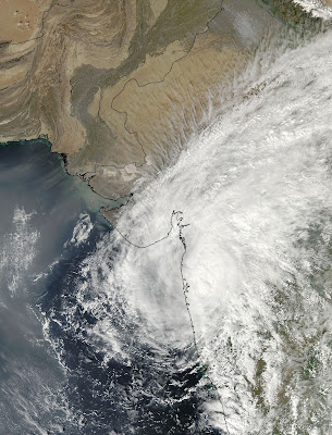
Cyclone Phyan broke a 43 year record when it made landfall north of the city of Mumbai, India during the evening hours on November 11. NASA's Aqua satellite captured Phyan's landfall with one instrument, and a day later, another of Aqua's instruments show the storm's remnants raining Tibet as Phyan continues to dissipate.
Phyan is the first tropical cyclone to make an appearance in November in the Konkan region of India since 1996. The India Meteorological Department confirmed that the last November appearance of a storm in that region was 43 years ago. As Phyan was making landfall, NASA's Aqua satellite passed overhead, and the Moderate Imaging Spectroradiometer captured a stunning visual image of the storm on November 11 at 0845 UTC (3:45 ET).
Today, November 12 at 1:30 p.m. local time (2:30 a.m. ET) another instrument on Aqua called the Atmospheric Infrared Sounder (AIRS) captured an image of Phyan's remnant cold clouds and showers over Tibet. The AIRS image showed that Phyan still had cold cloud tops as cold as -27F and was dumping moderate rainfall over Lake Manasarovar and Raksas Tal in Tibet.
The official final warning on Phyan was issued on November 11 at 1500 UTC (10 a.m. ET) from the U.S. Navy's Joint Typhoon Warning Center. Phyan's center was located near 19.2 degrees North latitude and 73.6 East longitude, about 30 miles east-northeast of Mumbai, India. Cyclone Phyan had maximum sustained winds near 40 knots (46 mph) and it was moving northeast near 16 mph.
According to Sifynews.com, before Phyan came ashore, the storm caused the deaths of seven fishermen. As of this morning, November 12, there are still 100 fisherman missing in the Arabian Sea because of the rough conditions the cyclone created on its approach to its landfall. Pyhan also affected the Sugar cane industry. Sugar cane harvesting was delayed because of flooded fields in Maharashtra, India’s second-biggest producer. Maharashtra is a state located on India's western coast. Other reports cited damages to more than 7,500 homes. Almost 100 were destroyed from Phyan's tropical storm force winds as wind gusts to 55 mph were reported upon Phyan's landfall. Phyan's remnants should dissipate over Tibet later today or tomorrow.